Parameter Maps
By:
Devenah Dawn Dagohoy
On
28/05/2024Reading time:
12 min
Summary:
Cyclonic wind vulnerability parameters were mapped using QGIS using the established feature weight of each parameter. The study generated 17 parameter maps and three cyclonic wind vulnerability maps. All the building attributes and the presence and number of obstructions were mapped per barangay, while the remaining location attributes presented the whole municipality.
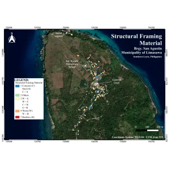
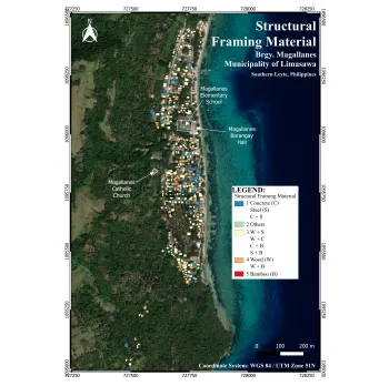
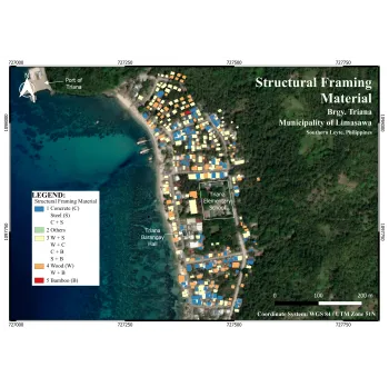
Structural Framing Material
The system of interconnected elements, including columns, beams, trusses, and slabs, provides a building with stability and transfers loads to the foundation (Acosta et al., 2014). The materials used in the structure can affect its vulnerability against strong winds. According to Haojie, Fengbo, & Guoqing (2017), light-frame low-rise buildings used for residential purposes are very vulnerable to high winds and may suffer significant damage.
The structural framing materials were classified into five categories. In all barangays, the common structural framing materials used in residential houses are concrete, wood, and a combination of the two.
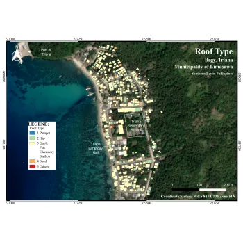
Roof Type
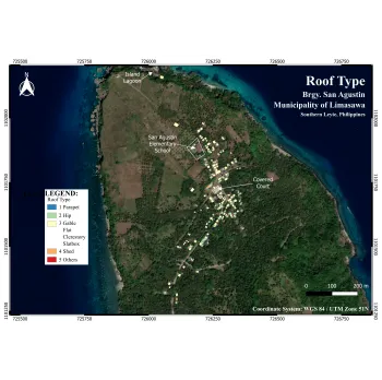
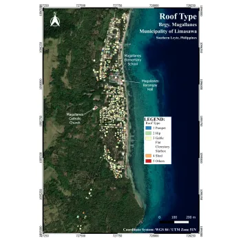
Roof shapes play a significant role in wind resistance and, thus, affect the vulnerability of the building. Different roof designs react to wind forces in varying ways (Papathoma-Köhle et al., 2023). The study of Keote et al. (2015) has shown that buildings with pyramidal roofs experience less upward wind pressure compared to those with gable or hipped roofs.
The researchers generated one roof type layer per barangay. The feature class was classified into a rating of 1-5 based on experts’ opinions. From the figure below, most houses in San Agustin have hip or gable roof types in Brgy. Triana and Magallanes, the majority have a gable roofing.
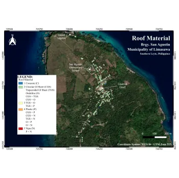
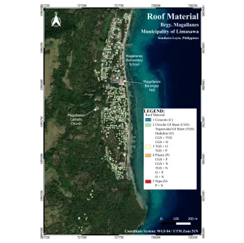
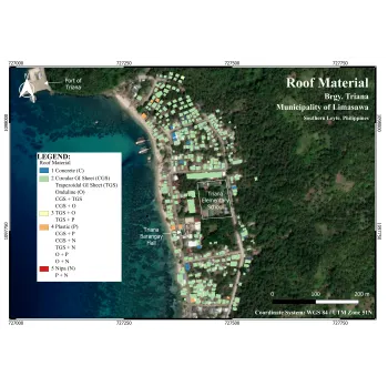
Roof Material
In their 2020 study, Karamlou and Ramanathan explored the relative vulnerability of two similar buildings in the Caribbean constructed with different roof cover materials. The study revealed that using light metal sheets can significantly increase a building's vulnerability to hurricane wind damage, while clay/concrete tiles and standing seam metal panels are considerably less vulnerable. The Family Income and Expenditure Survey (FIES) in the Philippines classifies roof and wall constructions into seven categories based on their strength. The weakest category comprises roofs of light materials such as nipa, anahaw, and cogon. Conversely, the least vulnerable against winds are classified as strong materials like galvanized iron, concrete, and tile.
As shown in the corresponding figures, the roof material layer was mapped per barangay. The same with the prior building attributes, the feature classes were categorized into five. From the gathered data, circular G.I. sheet is the most common roof material in all three barangays.
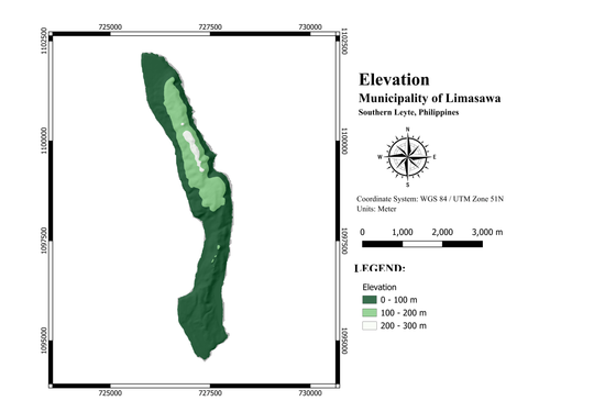
Elevation
According to Arca and Citiroglu (2020), the wind speed is likely to vary based on the elevation of the site. In Monteverde et al.’s (2014) article, "Component 4 - Tropical Cyclone Severe Wind Risk Analysis," it was found that people living at higher elevations are more susceptible to severe winds with higher wind speeds. The study by Arca & Citiroglu (2020) classified the elevation in terms of vulnerability to cyclonic winds into five: 0-100, 100-200, 200-300, 300-400, and greater than 400 meters. Since the highest elevation is 242. 931 meters based on the IFSAR-DEM data, the first three classifications were used in this study. The higher the elevation, the more vulnerable to cyclonic winds.
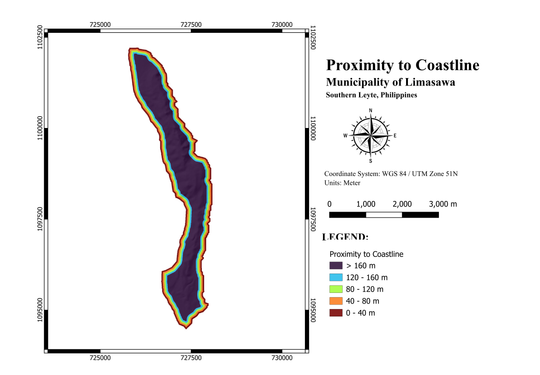
Proximity to Coastline
The assessment of cyclone vulnerability heavily relies on factors like proximity to coastline and cyclone tracks. Buildings and people near these areas are exposed to a much greater risk of damage and harm from cyclones than those further inland or outside typical cyclone paths (Hoque et al., 2019).
The proximity to coastline map for the study area is shown. The most vulnerable to cyclonic winds are those houses 40 meters from the coastline of the island. This distance is in accordance with the “No Build Zone” policy, which prohibits the construction of permanent structures within 40 meters from the shoreline. (Official Gazette of the Republic of the Philippines, 2014)
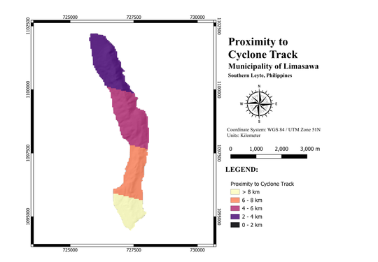
Proximity to Cyclone Track
The assessment of cyclone vulnerability heavily relies on factors like proximity to coastline and cyclone tracks. Buildings and people near these areas are exposed to a much greater risk of damage and harm from cyclones than those further inland or outside typical cyclone paths (Hoque et al., 2019).
The photo shows proximity to the cyclone track. Based on the cyclones from 2013-2023, the study area exhibited four various categories, with the southern tip of the island as the most vulnerable to cyclonic winds.
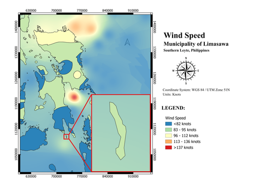
Wind Speed
Cyclone intensity depends on wind speed, which determines the potential damage to human habitation and natural resources in the region (Ali et al., 2019). This study adopted the Modified Tropical Cyclone Categories of the Philippine Atmospheric, Geophysical, and Astronomical Services Administration (PAGASA), which provides a 1 to 5 categorization based on the cyclone’s wind speed and potential property damage. Category 1 has a lower wind speed, corresponding to a minimal to minor threat to life and property. In contrast, the highest category (Category 5) has a wind speed of 185 kph or higher, which can cause severe to catastrophic damage.
As shown in the figure, the whole study area has a uniform vulnerability regarding wind speed since it was considered a single point due to its size.
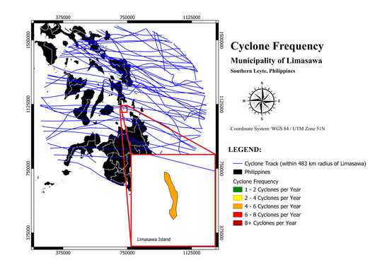
Cyclone Frequency
Cyclone frequency means the number of cyclones with time (Ali et al., 2019). It influences the hazard intensity for a particular area because compared with occasional or rarely occurring hazards, frequent cyclone hazards are likely to affect an area (Poompavai & Ramalingam, 2013).
A total of 47 cyclones were included in the analysis, those within 483 km radius of the study area. The number of cyclones was identified, and the average number of cyclones per year was 4.3. Since the island has a relatively small land area, it was considered a single point, thus, a uniform cyclone frequency throughout the study area.
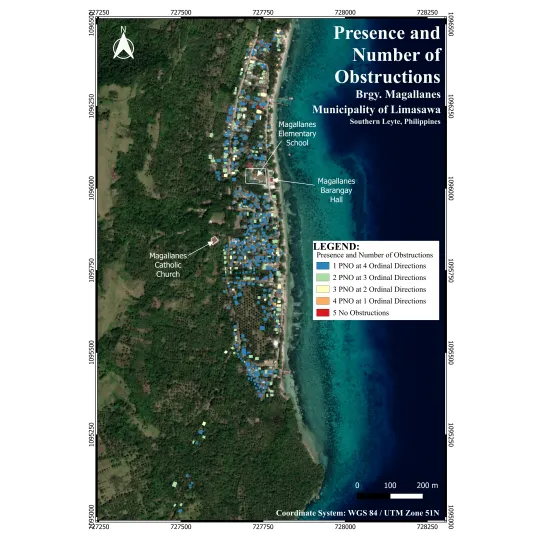
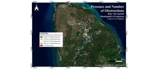
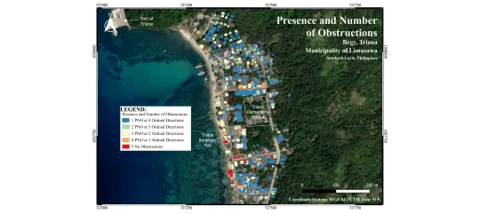
Presence and Number of Obstructions
Shielding or the presence and number of obstructions are the ways of protecting a building downwind from another structure. The more buildings upwind, the greater the shielding factor decreases wind velocity. A taller building shields a lower one and moderates wind speed (Monteverde et al., 2014).
In the study, there are five identified categories in assessing the vulnerability of residential houses against cyclonic winds in terms of presence and number of obstructions. In Brgy San Agustin, most houses have obstructions in four ordinal directions. This is because the area has plenty of trees. In Brgy. Triana and Magallanes, most houses were built close to each other, providing obstructions and shielding against strong winds